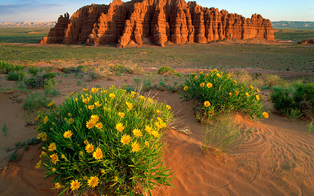
Mules Ears flowers bloom as an Entrada sandstone tower rises from the sands of the San Rafael Desert in southern Utah. This area receives a scant 5 inches of rain per year, but after a wet winter, the wildflower displays here are some of the best in the region.
Whenever I’m traveling outside the U.S. and someone asks me where I’m from, and I say, “Utah,” their face often lights up as they launch into a story about how they recently took this “incredible, amazing” trip there where they ran whitewater rapids on the Colorado River near Moab and then traversed along the edge of a 1,000-foot drop-off on their way to the top of Angels Landing in Zion National Park. They go on to describe how they walked through huge sandstone arches and rode their mountain bikes across an endless sea of sandstone beneath 13,000-foot snowcapped peaks. As their story concludes, they usually add the words “busy,” “crowded” and “long lines,” just before mentioning that they can’t wait to go back.
This attraction to Moab and Zion is not limited to international visitors. Every American family organizing their first trip to Utah will very likely have these two locations at the top of their wish list, and it’s easy to understand why. Each year, countless pages of magazine ads around the globe showcase the wonders of southern Utah, relying heavily on promoting our five national parks, dubbed “The Mighty 5” by Utah’s Office of Tourism. These ads act like giant tractor beams, drawing in visitors from all over the world. Even among Utah residents, the Zion and Moab regions are often the only choices considered for outdoor adventure in southern Utah. It’s as if everything outside these locations is a vast terra incognita, a blank space on their travel map—even though they see an endless array of cliffs, mesas and canyons flashing past their car windows as they drive home.
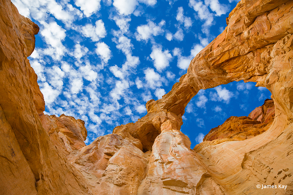
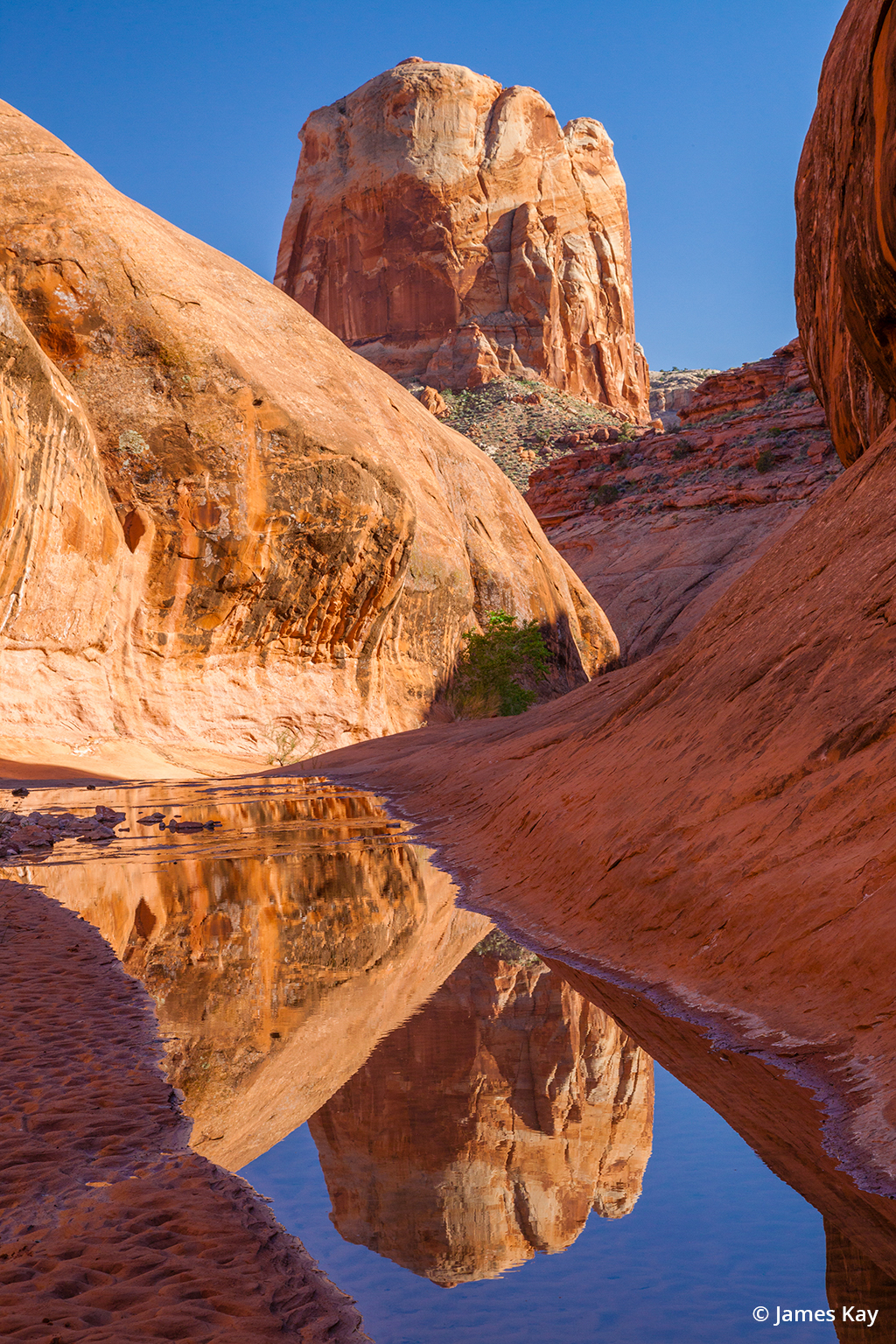
Sandstone arch, Paria Canyons, Grand Staircase-Escalante National Monument. While Arches National Park contains the motherlode of arches, these formations can be found throughout the canyons of both the Escalante and Paria Rivers.
I felt this same attraction the first time I ventured to southern Utah over 40 years ago. Even back then, everyone said, “You gotta go to Moab,” so, of course, that was the first red rock country I chose to visit, right there beside the golden, flowing Colorado River and the wonders of Arches National Park. In those days, there were perhaps one or two cars lined up at the park’s entry gate, and you could always find empty campsites any midweek day in the park’s small campground, with no reservations required. Imagine that.
When I first arrived in Utah in the early 1970s, the state’s population clocked in at slightly more than 1 million people; it’s around 3.5 million today. The trouble is, those same five national parks haven’t grown in size by one square inch. Zion’s visitation has increased from fewer than 1 million annual visitors in the 1970s to over 5 million last year. Over the last two years, COVID poured gasoline onto that fire.
There’s So Much More To See
Throughout my 40 years of photography across the Colorado Plateau region, I’ve added more and more locations to my “no-go” list due to these ever-increasing crowds. These are my three most indelible memories. My last attempt to photograph Delicate Arch in Arches National Park was over 30 years ago. Prior to that, I had only seen a handful of people there, but on that lovely evening, I was joined by more than 300 other visitors. Fortunately, the clone tool had just been invented by Photoshop’s engineers, so I was able to remove some of the more annoying characters who were dancing under the arch as their lives were being threatened by other photographers on the scene. On that same trip, I said goodbye, forever, to Mesa Arch in Canyonlands National Park when I found the roadside pull-out overflowing with cars one hour before sunrise. And then there was my last trip to Antelope Canyon over 20 years ago. On my first trip there in the early 1990s, my wife, Susie, and I drove along the sandy wash in our own vehicle and were the only people in the entire canyon. On that last visit, with perhaps 50 other people wandering around, I witnessed two guys almost get into a fistfight because they were in each other’s way trying to photograph the light beam. That was it. I was done with Antelope
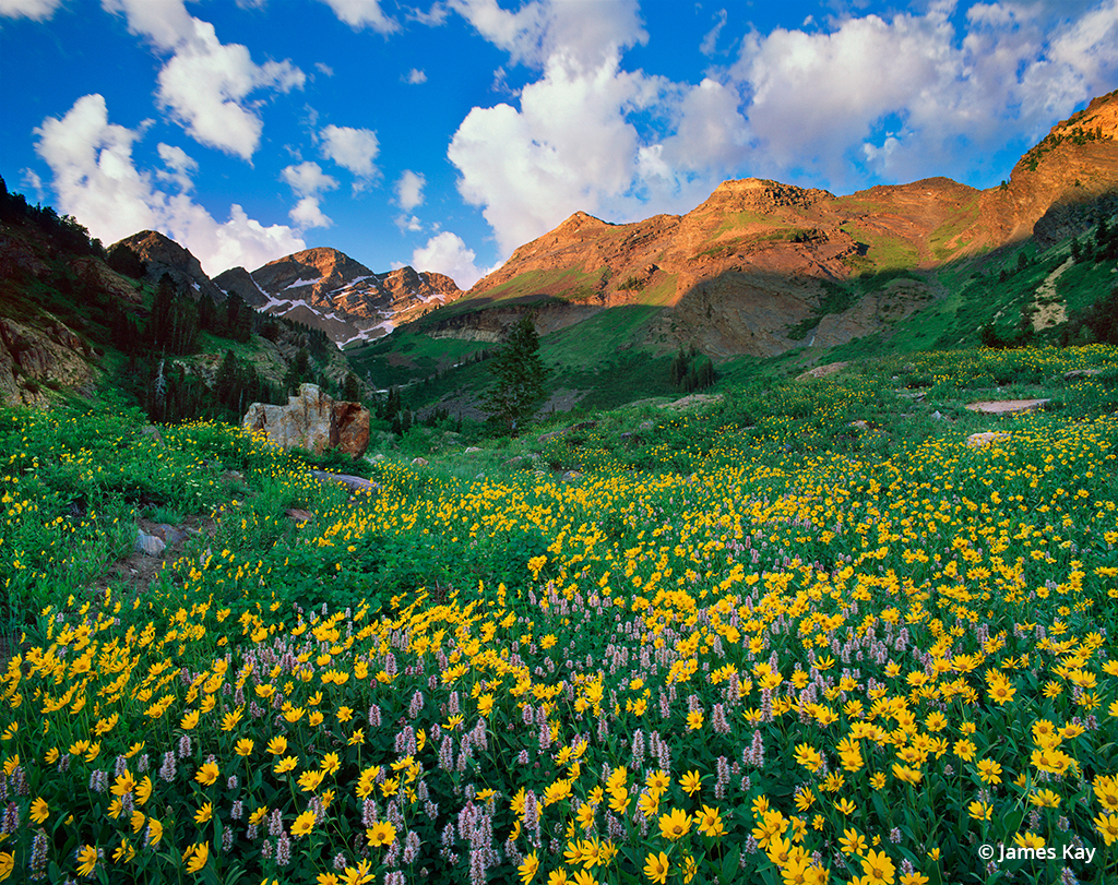
Arrow Leaf Balsam fills a meadow below Twin Peaks in the Twin Peaks Wilderness Area, Wasatch Mountains, Utah. With 22 summits rising 11,000 to 12,000 feet into the northern Utah sky along with an extensive network of trails, these glacier-carved mountains contain some of the best wildflower displays in the West.
Of course, these scenes aren’t limited to Utah’s parks, and I’m fully aware of my complicity in all this due to all my published photos over the years. While I’ve always made a point not to reveal specific locations on many of these images, I’ve done as much as anyone in promoting this region. Yes, the planet has become a lot more crowded in the last 40 years, but as primates, we are herd animals, so we tend to flock to the same tiny locations on the planet’s surface. Think Venice and Waikiki Beach. Sure, these places are gorgeous, but at some point, their beauty is overwhelmed by the teeming hordes. In the same way, Utah’s national parks are tiny in scale, only representing 1.5 percent of the state’s total acreage while Utah, as a whole, is mostly a vast, empty landscape with tens of thousands of square miles of fantastical geologic formations, countless empty canyons, wild rivers and snow-capped peaks. In other words, there is much to see outside the borders of “The Mighty 5.
There’s the argument that perhaps it’s better to pack people into these small, sacrifice zones and leave the vast majority of the land alone. But if you’d rather create unique images as a photographer, instead of just producing more of the same, the idea is to think outside the box. Thirty years ago, when I was pondering those people dancing under Delicate Arch, I remember thinking to myself, “What’s the point in capturing the 20 billionth image of this arch?” We normally determine the value of something based on its beauty and rarity. If there were 10 trillion tons of gold in the world, it would be as worthless as sand. Other than a memory from a vacation, what’s the value in that 20 billionth image?
Thinking outside the national parks where all your services are provided takes a little more imagination and logistical planning—and a capable 4WD wouldn’t be a bad idea, either. You’ll need to buy some maps, camping gear and perhaps hook up with a fellow photographer to help dig you out if you get stuck in the sand. If you’re ready to take the leap, consider this short list of some of my favorite off-the-beaten-path Utah locations.
San Rafael Desert
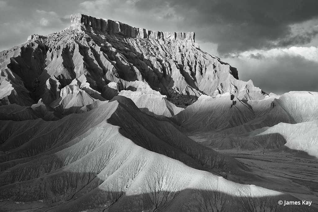
North Caineville Mesa, San Rafael Desert, Utah. Carved from the same Blue Gate Shale formation as the more-well known and nearby Factory Butte, this desolate but beautiful area contains many photo opportunities along the highway, from Hanksville to Capitol Reef National Park. Backcountry roads leave the highway in several locations if you really want to get away from the crowds. Low-angle sidelight best accentuates these sensuous forms.
Never heard of this place, right? I began photographing this region in south-central Utah many decades ago. Goblin Valley State Park is perhaps the most recognizable destination in the area. Bounded by the canyons of the Green River and Canyonlands National Park to the east and the sandstone fins of the San Rafael Reef and the Henry Mountains to the west, the San Rafael Desert contains countless empty canyons, sand dune fields and beautiful sandstone formations. State highways 95 and 276 slice right across the center of this region with a handful of well-graded dirt roads branching off these paved highways. On the east side, one road eventually leads to the Maze district of Canyonlands National Park as it skirts the rim of Dirty Devil, another place few people have ever heard of. Once you’re away from the main highway, you’ll have an ample choice of locations to set up a car camp.
The centrally located, very small hamlet of Hanksville offers basic services with one or two small motels if you’d rather not sleep in the back of your truck. Just west of town, the Blue Gate Shale, with its sensuous curves, forms the beautifully eroded base of Factory Butte, which is a photographer magnet in its own right. This same shale formation lines both sides of the road for many miles west of Hanksville in the forms of North and South Caineville Mesas.
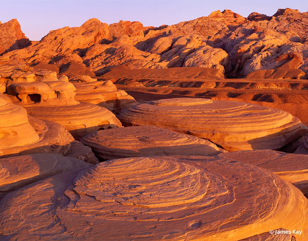
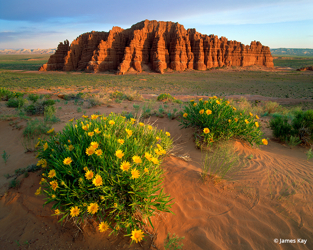
Sunrise on the San Rafael Reef, San Rafael Desert, Utah. While identical in structure but not quite as extensive as the 100-mile-long Waterpocket Fold of Capitol Reef National Park, this geologic feature contains countless narrow canyons and beautiful sandstone formations west of the town of Green River, Utah.
Just south of Hanksville and named after Joseph Henry, the first director of the Smithsonian Institution, the 11,000-foot Henry Mountains are also worth a look. They are similar to but less dramatic than the La Sal Mountains above Moab, and you’ll run into more cows than cars along the range’s dirt roads. There are virtually no established hiking trails, but the 360-degree views from any of the five main summits take in a large portion of southcentral Utah from Capitol Reef’s Waterpocket Fold in the west to the La Sal Mountains in the east.
Paria & Escalante River Canyons
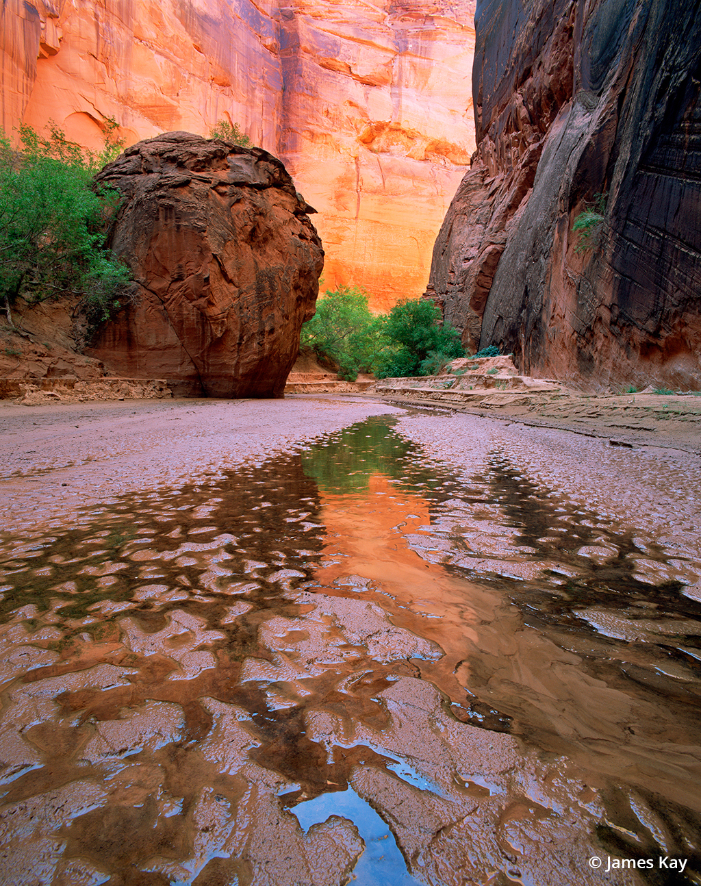
Paria Canyon Narrows. The diminutive Paria River has carved an extensive network of canyons from its headwaters in Bryce Canyon to its confluence with the Colorado River just upstream of the Grand Canyon. You’ll need a backpack and a tent to explore most of it. A daily limit of 20 people keeps the crowds at bay.
The Paria and Escalante Rivers and their tributaries have carved a sprawling network of redrock canyons across Grand Staircase-Escalante National Monument (GSENM). The beauty of these canyons is, in fact, the reason GSENM was established in the first place. Extending from the eastern border of Bryce Canyon National Park to the western edge of Capitol Reef NP, GSENM covers a wild and diverse landscape, with 99.9 percent of it devoid of crowds. To get an idea of just how large the monument is, if you were to double the size of all five Utah national parks and put that combined area inside the boundaries of GSENM, you’d have room to spare. While GSENM is well known to many photographers, few people stray far from paved Utah State Highway 12 along its northern boundary. Along with a rudimentary paved section of the Burr Trail and a short portion of Highway 89 in the south, all other roads in the monument vary from well-graded gravel to rugged 4WD tracks. There are a few very small towns around the periphery of the monument, each with a couple gas stations, a few hotels and other limited services.
The Escalante River system is a dendritic network of canyons that would take many, many lifetimes to explore. Beginning as a well-graded road south of the town of Escalante and deteriorating into a rough 4WD track the further you travel, Hole-in-the-Rock Road provides access to these canyons. Much of the southern portion of the Escalante lies within Glen Canyon National Recreation Area, which surrounds the vastly depleted waters of Lake Powell. Glen Canyon was the motherlode of gorgeous narrow canyons in southern Utah until flooded by the waters of Powell, but many of the canyons are now being exposed to the light of day as the waters of the reservoir continue to recede due to the relentless, ongoing drought. These very photogenic canyons can be accessed by boat from the reservoir or via often-arduous overland routes.
Escalante Canyons, Glen Canyon National Recreation Area, Utah. Over the ages, the Escalante River has carved a vast network of wild and remote canyons from its headwaters on the 11,000-foot Aquarius Plateau in the north to the waters of Lake Powell in the south. It would take multiple lifetimes to explore them all.
The Escalante Canyons are separated from the Paria Canyons by the Kaiparowits Plateau, one of the most remote regions in the 48 states and a favorite hunting ground for paleontologists searching for new dinosaur species. From the deep, narrow canyons of the lower Paria to its headwaters in the hoodoo-filled amphitheaters of Bryce Canyon National Park, the Paria Canyons can be accessed using the usually well-graded Cottonwood Wash Road or Skutumpah Road, which leave the main highway at Cannonville, just east of Bryce. A 4WD vehicle would be a very good idea.
La Sal, Uinta & Wasatch Mountains
If your conception of Utah is based solely on those “Mighty 5” magazine ads, no one could fault you for thinking that Utah is nothing more than an endless ocean of red rock. You would likely be surprised to learn about the state’s many mountain ranges, some popping up right in the middle of the Colorado Plateau, such as Moab’s 13,000-foot-tall La Sal range with its vast aspen groves and far fewer people than the nearby national parks. Four hours north of Moab, the Wasatch Mountains tower above the Salt Lake Valley with some of the best wildflower displays and autumn colors in the American West. The Uinta Mountains—Utah’s highest, just east of the Wasatch Range—reach more than 13,500 feet into the sky, with countless lakes and glacier-carved peaks reminiscent of the northern Rockies.
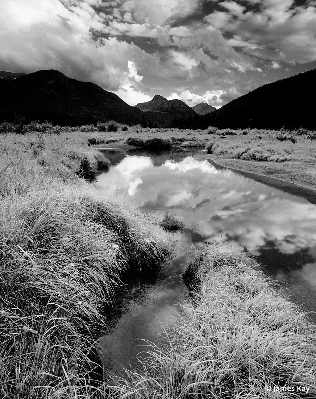
Bear River, Uinta Mountains, Utah. While the Wasatch Range grabs all the attention with its ski resorts and proximity to Salt Lake City, the Uinta Mountains are far more extensive in size, 2,000 feet higher and contain the largest official wilderness area in the state. With countless lakes and glacier-carved peaks, the range is reminiscent of the northern Rockies of Montana.
To sum things up, I’ll let Gary Larson lend me a hand. Perhaps you’ve seen his greeting card with the guy standing at a fork in the trail. The right fork has a sign that says, “Beaten Path,” and the other fork says, “Off.” It’s one of my favorite cards and a perfect metaphor for avoiding the crowds at our national parks today.
See more of James Kay’s work and learn about his workshops at jameskay.com.
The post Wildlands Of Utah appeared first on Outdoor Photographer.